- Nova Scotia
- Nova Scotia Hiking
- Clyburn Valley Trail
Hike the Clyburn Valley Trail
& search for gold
The Clyburn Valley trail is a restful hike. There are no steep mountains to climb or descend. This is also a great family hike. The kids will love the adventure of hiking to an old gold mine.

The Yukon is not the only place that has abandoned gold mines. Come to the Clyburn Valley trail in the Cape Breton Highlands National Park and you will see a place that will take you back to a time when finding gold was in the dreams of everyone.
|
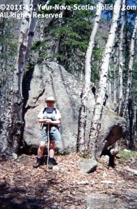
The Clyburn River Valley was the site of a gold mining operation at the turn of the century. Although gold was never actually discovered; a gold mining operation did exist for a couple of years. It closed in 1916. The giant size boulders you will find along the trail will certainly impress the young hikers. The opportunity to hike to an abandoned gold mine may be a perfect way to get your kids interested in hiking. This is an ideal way to spark adventure in any young person. |
 |
Before you go…
Directions: Follow the Cabot Trail through Ingonish Beach, drive past the church, once you cross the small bridge, you will see the sign for the Clyburn Valley Trail (hike #24 in the park), turn left into the parking lot.
This trail is in the Cape Breton Highlands National Park so you will need to pay a fee when you enter the park in Ingonish.
The trail actually starts about 2.5 km from the parking lot; however, the road was closed the two times that I was there. Starting at the parking lot adds 5 km to the trail.
Don’t let this additional part scare you. It is a wonderful addition to the hike since you walk along the Clyburn River the whole way. My recommended hike starts at the first parking lot.
Distance: 14 km return.
Time: 3.5 - 4 hours. This can be longer if you stop along the Clyburn River to picnic or if you decide to explore the ruins of the old gold mine.
Level of Difficulty: Easy to moderate; mostly level terrain but the walking can get difficult due to large rocks left in the trail from the spring run-off from the highlands.
Food/Water: Water is always needed on any type of hike; if you plan to be hiking for more than 3 hours I suggest you take some food; a light lunch by the river is extremely enjoyable.
Clothes: A sweater or light jacket; hiking boots; insect repellent.
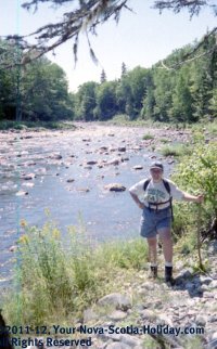 |
Let’s Get Hiking... As you park your car, look around for the trail map. The hiking trail starts to the left. You will descend a small hill and be at level with the Clyburn River. For the first part of the hike, you will actually walk parallel to the Clyburn River. The river is a wonderful, crystal clear picture of Cape Breton nature. The water is the clearest that I have ever seen. Watch for golf carts as the Highlands Links golf course is in close proximity to the start of the Clyburn Valley trail. This golf course is one of the best in Canada. It is definitely worth it to try some golf while you are in Ingonish. |
It took us about 45 minutes from the first parking lot to get to a metal gate which indicates the official start of the Clyburn Valley trail. We walked beside the river for a good part of this time.
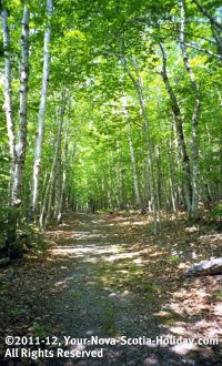
The walking along this part of the trail is very good. There is a good supply of shade from the trees.
There is great salmon fishing in the river so watch for fly fishermen as well. We saw one during our first trip. Watching a fly fishermen cast his rod is truly magical.
Only fly-fishing is permitted in the river so resist the temptation to bring along your fishing rod.

You should arrive at the old abandoned gold mine about 30 minutes after you reach the gate. Eventually you will loose the river and you will find yourself deep in the Cape Breton highlands. Specifically, you are in the Clyburn Valley!
The forest is wonderful during this hike. The sunlight peering through the branches gives unique shading. We did this hike in early summer. The colors must be spectacular during the fall.
You will know that you have reached the gold mine when you see a small building with a sign, Gold Mine. The building is now an emergency shelter. It is very well organized with a wood stove and benches.
|
Firewood should be plentiful through the door to your left. There is also a guestbook in the shelter. Make sure you leave a message. We read through the book each time we do this trail. Spend some time wondering around the site. You might get lucky and find a gold nugget or two!! Remember that the Clyburn Valley trail is about searching for gold! |
 |
The trail continues for about 3 km past the shelter. You should find yourself beside the Clyburn River at the end of the trail. This is a good place for that picnic.
You may notice on some maps that the mountain in front of you is called Klondike Mountain. Very appropriate!
Return to the parking lot by the same route.
Hope you enjoyed hiking the Clyburn Valley trail. Want to tell me about it?? You sure can.....see below to find out how!!
- Nova Scotia
- Nova Scotia Hiking
- Clyburn Valley Trail
Have you hiked the Clyburn Valley?
Do you have a great story about it? Please share it with us!
Please share this page with your friends.