- Nova Scotia
- Nova Scotia Hiking
- Mabou Highlands
Mabou Highlands
...a hiking adventure...
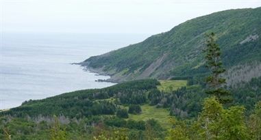
The hiking trails of the Cape Mabou Highlands will give you mountain top views of the Atlantic ocean coastline and the highlands that are breathtaking. This is some of the best hiking that you will find anywhere in Nova Scotia.
However, these trails are challenging so be prepared for some steep climbs AND some awesome views!
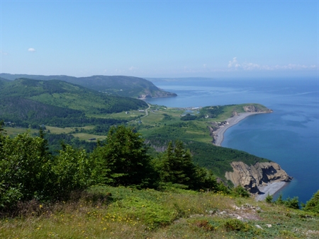
The highlands are a 20-square kilometre system of coastal and inland trails near the village of Mabou. The elevation of the Mabou Highlands is about 335 metres (1090 ft).
The Cape Mabou Trail Club has been maintaining these trails since 1993. They publish an excellent map of the trails system. You can purchase the map for about $5 at local businesses in Mabou and the Visitors Information Centre in Inverness. This is an excellent map with loads of information.
I do not recommend hiking into these highlands without this map.
Before we go:
Directions: The Cape Mabou Highlands are located near the village of Mabou. Mabou is on the Ceilidh Trail (Route 19) which is on the west coast of Cape Breton. You'll find it about 59 kilometers (37 mi) from the Canso Causeway which is where you enter Cape Breton.
You’ll see the signs for Route 19 right away after you cross the Canso Causeway. Check out the map of the Ceilidh Trail.
|
The map of the trails system will give you detailed information of how to get to the trailheads. GPS coordinates are included on the map. This map is an excellent resource for anyone wishing to explore the Mabou Highlands. The sale of the map by the Cape Mabou Trail Club generates revenue that allows them to maintain the trails. |
 |
Level of difficulty: The trails are rated from easy to very difficult. This is mostly due to steepness and elevation. Some of the trails are near cliffs and drop-offs and there can be significant erosion from one year to the next so extreme caution is necessary.
Length & time required: The trails vary in length from 2-7 kms but don't let this fool you since there are many hiking loops in the trails system. I can't imagine spending less than 3-4 hours hiking here.
Food/Water: Water is always necessary. I would definitely suggest taking snacks.
Clothes/Accessories: The weather along this coastline can be very unpredictable. Check the weather forecast beforehand. A sweater or light jacket and raingear are a good idea. It can be very windy and the clouds can move in very quickly.
Hiking boots are a must; walking stick for balance along the cliffs; and, don’t forget the binoculars and camera.
Facilities: There are parking places at the 3 trailheads. There are no other facilities.
Ok! let's get hiking!
There are three main access points which act as trailheads to the Cape Mabou Trails:
- one from the Inverness end through Sight Point Road,
- the 2nd from Cape Mabou, and
- the 3rd which is the most accessible and popular on Mabou Post Road (known as Mabou Mines).
There are about 17 or so trails, but not all may be open at any given time. The trail club works hard to maintain as many as possible open and in good condition. A constant effort is needed to keep ahead of windfalls and thick growth.
A map at the trailheads will reveal which trails are indeed open. The trailheads also include information on loop trails with return distances to the trailhead.
The Fair Alistair’s Trail, which leaves from the parking spot at the Mabou Mines trailhead, is probably the one most hiked due to its location at the trailhead and the beautiful view from the lookoff at the top of the trail. It is about a 30 minute hike to the lookoff.
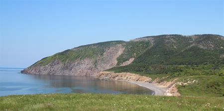
The Fair Alistair’s, MacKinnon’s Brook, and Steep Mountain (Beinn Bhiorach) trails provide the most ocean views.
Several of the other trails follow old cart tracks and take the hiker through beautiful hardwood forests. There are many looping options open to the hiker, and one can spend as little or as much time as they choose.
The trail system is hiking only, and camping and fires are not allowed and would be considered a major hazard. Hikers are also advised to be very careful at the MacKinnon’s Brook shoreline due to the erosion of the overhanging rocks.
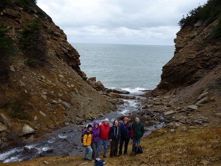 One of the descents to the ocean
You may also find yourself on private land while hiking here. Please respect the property by keeping to trails marked with standard green lettered signs and by following trail arrows.
Cape Mabou Trails have a facebook page (Cape Mabou Trail Club). They'll certainly have updates about which trails are open. Many thanks to the Cape Mabou Trails club for sending me information about the trails and the pictures.
After the hike
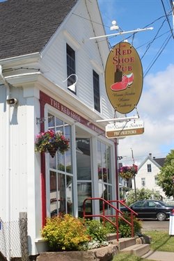 The Red Shoe Pub The Red Shoe Pub |
The village of Mabou is a wonderful place to stay a couple of days. I stayed at the Mabou River Inn when I was there and it was great. My Mabou page also lists the regular weekly ceilidhs and square dances in the area. Something everyone should experience. And don't forget to check out The Red Shoe Pub. It is quite well known, has great food and has entertainment all summer long. The Mothers of Sorrows Shrine in the village is also a unique place to visit. |
There are also other hiking adventures in the area. Check out the Celtic Shores Coastal trail which extends for 92 km through Mabou.
The Cape Breton Highlands National Park is 80 km (49 mi) north of Mabou. This park offers some of the best hiking in Nova Scotia. Be sure to stop at the visitor centre to get a map of the trails.
- Nova Scotia
- Nova Scotia Hiking
- Mabou Highlands
Have you hiked the Mabou Highlands?
Do you have a great story about it? Please share it with us!
What Other Folks Have Said
Click below to see contributions from other visitors to this page...
Whales & Mountains 
On October 8th, 2016 I woke up while camping in the Creignish area.
I could hear and see about 2 dozen Pilot whales off shore in a feeding frenzy. I …
Beinn Bhiorach (Mabou Highlands) Not rated yet
We made the trek as a class trip in High School. It was amazing!! The view from the top of Steep Mountain is still memorable, 16 years later. Parts were …
Please share this page with your friends.