- Nova Scotia
- Nova Scotia Hiking
- Cheticamp hiking trails
Cheticamp Hiking Trails
...get into the highlands...
There are several Cheticamp hiking trails on the western side of the Cape Breton Highlands National Park not far from the small acadian village of Cheticamp. You'll actually be on the world-famous Cabot Trail while inside the park and in the village.
I love hiking in the Cheticamp area. You are close to the ocean and the highlands so it is perfect hiking destination.
These are all great hikes. You'll have breathtaking views of the ocean and the coast. You'll be taken deep into the highlands to see waterfalls and salmon pools and you'll hike on the plateau to see rare plants and fauna.
You might even see a moose!!

All of these trails are in the Cape Breton Highlands National Park. You'll need to get a visitor's pass at the entrance to the park in Cheticamp.
The VIC at the Cheticamp park entrance will also have maps for you. They don't have a lot of detail but they'll show you where the hikes are located in the park. The panels at the hike trailheads will give you more information on the specific hike.
Don't forget to get the FREE map of the park at the VIC.....it is extremely useful! Parks Canada has allowed me to include links to 2 portions of the parks map for this area.
The first shows the village of Cheticamp and the location of several trails. The 2nd shows French and MacKenzie Mountains and the trails there.
Don't forget that you can download the entire map from my Cape Breton Highlands Park page to your laptop or mobile device.
Some things to remember when hiking in the Cape Breton Highlands Park:
- weather conditions can change quickly
- always have a sweater or jacket
- a rain poncho is always a good idea
- don't forget to bring water and something to eat
- do not do any of these trails in summer footwear
- hiking boots or sturdy shoes are necessary!
- I always wear a hat when I hike.....a Tilley hat, that is!!
Oops almost forgot.....don't forget the camera and binoculars for the view.
I have listed the Cheticamp hiking trails in 3 categories:
- Trails with panoramique ocean views
- Short trails
- Relatively flat trails with some elevation
The number that I indicate in brackets beside the name of the hike corresponds to the number of the hike in the park. All of these hikes are clearly indicated on the map link.
You will also be able to easily find them as you drive on the Cabot Trail and through the park. The directional panels are very well placed and easily seen.
Panoramique ocean views
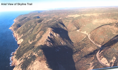
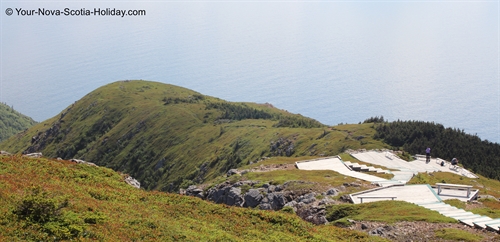
The Skyline (#7 on the park map)
7km (4.3mi) loop; 2-3 hours; elevation 320-400m (1050-1350ft)
EASY TO MODERATE LEVEL
This is a relatively flat trail with absolutely gorgeous views of the ocean. It is one of the most popular hikes in the park and is accessible for everyone.
I have a page just for the Skyline Trail!! Check it out!!
The Acadien (#1 on the park map)
9.6km (6mi) return; 3.5-4 hours; elevation 0-365m (1150ft)
MODERATE TO DIFFICULT LEVEL
This is a great trail but is more difficult than the Skyline due to the change in elevation and the length. However, if you are good physical condition then this trail is worth it. My page on the Acadian trail will give you all of the details that you will need.
Awesome views of the ocean with Cheticamp to the south. This is Cheticamp hiking at its best.
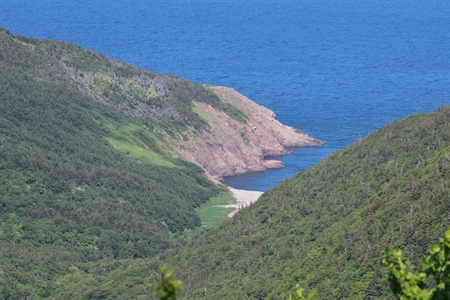
Fishing Cove (#10 on the park map)
16km (10mi) return; 4-5 hours; elevation 0-300m (0-1100ft)
MODERATE TO DIFFICULT LEVEL
This is an awesome trail. If you love the adventure of challenging hiking this is the hike for you. I will call it a difficult hike because of the distance and change in elevation but it is also worth it. There is a steep descent into the cove near the end of the hike.
There is the added bonus of being able to camp at Fishing Cove since it is designated as a backcountry camping site. Remember that you need a permit!
There is an alternate hiking trail to Fishing Cove which is further north on MacKenzie Mountain. It is 5.7 km (3.5mi) return.
Short Trails
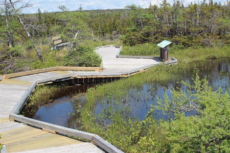
The Bog (#8 on the park map)
0.6km (0.4mi) loop on a boardwalk; 20-30 minutes to complete; no change in elevation
VERY EASY & WHEELCHAIR ACCESSIBLE
This short trail is located on the plateau on French Mountain which gives it a very unique character. Rare plants and flowers can be seen here. Look closely and don’t be in a hurry.
This special trail is also wheelchair accessible. I was there several years ago with a lady in her 80s and she loved it.
Benjie’s Lake (#9 on the park map)
3.2 km (2 mi) return); 1-1.5 hours; no change in elevation
EASY
This level trail is located not far from the Bog so the two trails can be done in the same trip. Both are suitable for all levels and give you a chance to explore the plateau on French Mountain.
There are some boardwalks on this trail where the sections are wet and muddy. The trail leads to a small lake. You will see lots of fauna and maybe even a moose!!
Relatively flat trails with some elevation
The Buttereau (#5 on the park map)
1.9km (1.2mi) return; 45-60 minutes to complete; elevation 15-122m (50-400ft); EASY LEVEL
This is an easy trail and is close to the ocean. You’ll walk through an old Acadian forest. Look closely, you’ll see old foundation ruins. Acadian families used to live here.
There are interpretive panels and plaques along the trail. If you don’t have a lot of time then this is a good choice for a short hike. It is just across from the Grande Falaise picnic area.
The chemin du Buttereau (#3 on the park map)
5km (3mi) return; 1.5-2 hours; elevation 15-122m (40-400ft); EASY TO MODERATE
The Chemin du Buttereau connects to the Buttereau which could make it a very interesting hike. Similar to the Buttereau you’ll see foundations of old Acadian settlements. There are great views of the Cheticamp River along this trails with open fields and pastures.
You’ll meet up with The Buttereau trail as you get closer to the ocean. You could actually do the loop section of the Buttereau which takes you closer to the water before returning.
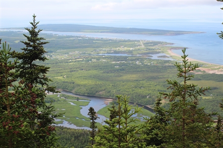
Salmon Pools (#2 on the park map)
12.2 km (7.6 mi) return; 4-5 hours; elevation 15-75 m (50-330 ft); MODERATE
I am going to say moderate level for this hike because of the length and time for completion. But you can return at any time since it is a return trip. This is suitable for all levels and is a magnificent hike along the Cheticamp River. Canyons walls will rise above you for 1300 feet.
There are 3 fishing pools along this hike so be prepared to watch fishermen do their thing!! You may even see some salmon in the pools. This really is Cheticamp hiking at its best!
One thing to remember on this trail is that mountain bikes are permitted as far as the 2nd pool. This hike is perfect if you are camping at the Cheticamp campground as the trailhead is in the campground.
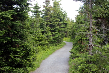
Corney Brook (#6 on the park map)
8km (5mi) return; 2-2.5 hours; elevation 30-170m (100-560 ft); EASY TO MODERATE
This is a very good trail and is suitable for most skills. If you don’t consider yourself a hiker but you want to experience hiking and see a waterfall then this is a hike for you.
It is actually a box river canyon and you’ll have cliffs high above you as you start this hike. There is a slow steady climb but it is very doable and the trail is very well-maintained.
The trailhead is located directly across from the Corney Brook campground which is about 15km from Cheticamp.
This is a great part of Cape Breton and the Cabot Trail to explore. There is a lot to see and do. Spend some time here if you can. Please don't just drive through......stop and experience this special place.
Cheticamp is a full service community with accommodations, restaurants, banks, grocery stores. There are also special activities through the summer months.
The Cape Breton Highlands National Park offers wonderful services in the Cheticamp area including campgrounds. Why not check it out and stay awhile.............and then write to me and tell me all about it!!
- Nova Scotia
- Nova Scotia Hiking
- Cheticamp hiking trails
Have you hiked trails
in the Cheticamp area?
Do you have a great story about it? Please share it with us!
Please share this page with your friends.